
Nepal's top famous trekking routes that can be hiked on self-guided basis
Because I have 3 months multiple entry tourist visa granted on my first visit to Nepal, I have more than enough time to trek Annapurna Circuit (2016) and Lantang Valley (2016), two famous trekking routes in Himalayas Region.
Annapurna Circuit and Lantang Valley from Nepal are two of the most popular mountain trails and tourist-hiker friendly trails in Nepal's Himalayan Range. As an amateur hiker, this two mountains are the top-most priority on the bucket list. As such, I visited them both and the following was the observation I had during the course.
To summarize Nepal's famous 3 trekking routes (Everest Base Camp, Annapurna Circuit and Lantang Valley) based on my self-guided solo winter hike adventure in comparison to each other; LANTANG VALLEY (3,830masl) and KYANJIN PEAK (4,773masl) trekking route is the under-rated trail but the most unspoiled trail ideal for mountain meditation trekking, those who are looking for "off-the-beaten path". At least 6 trekking days and has the most stunning 360degree view on the peak. On the other hand, ANNAPURNA CIRCUIT (5,416masl) and BASE CAMP (4,130masl) trekking route is the mainstream trail based of its tolerable high elevation for all tourist types and can be minimized to at least 7 trekking days for ABC only. Also, trail is much scenic and somehow easy because of continuous ascent/descent trails.
 |
| Annapurna Circuit (January 2016) |
 |
| Annapurna Circuit (January 2016) |
 |
| Annapurna Circuit (January 2016) |
 |
| Annapurna Circuit (January 2016) |
 |
| Annapurna Circuit (January 2016) |
| ANNAPURNA CIRCUIT | MOUNTAIN NAME | LANGTANG VALLEY |
| 5,416masl (Thorong La) | SUMMIT ELEVATION | 3,830masl (Kyanjin Gumba) |
| 4,130masl (Annapurna Base Camp) | 4,773masl (Kyanjin Ri) | |
| Annapurna, Nepal | LOCATION | Langtang, Nepal |
| see world's 10th highest, Annapurna I | FEATURE | |
| November to May | BEST MONTHS TO HIKE | November to May |
| June to August | WORST MONTHS TO HIKE | June to August |
| 8 days minimum | TREKKING DURATION | 7 days minimum |
| Short Route (Pokhara to ABC) | TRAILS | Short Route (Syabrubesi to Kyanjin Ri) |
| Long Route (Besisahar to Pokhara) | Long Route (Syabrubesi to Helambu) | |
| rainforest, rocky, dusty, alpine | TRAIL TYPE | rainforest, rocky, dusty, alpine |
| continuously ascent then descent | continuously ascent then descent | |
| lots of man-made shelters | TRAIL STOP-OVERS | lots of man-made shelters |
| tea houses and lodges | tea houses and lodges | |
| white/red rectangle paint | TRAIL MARKERS | poorly marked |
| can be done independently | HIKE JOURNEY | can be done independently |
| $320 | ESTIMATED MINIMUM BUDGET | $143 |
| none if independent | PREPARATION | none if independent |
| trekking & park permits required | REGISTRATION | trekking & park permits required |
| JANUARY 06 TO 21, 2016 | DATE I VISITED | JANUARY 30 TO FEBRUARY 04, 2016 |
| solo (no guide/porter) | HIKE JOURNEY | solo (no guide/porter) |
| Long Route (Besisahar to Pokhara) | CHOSEN TRAIL | Short Route (Syabrubesi to Kyanjin Ri) |
| self-customized | CHOSEN TRAIL REMARKS | self-customized |
| 16 days | TREK DURATION | 6 days |
| Easy to Difficult | TREK DIFFICULTY | Easy to Difficult |
| 280 kilometers (approx.) | TRAIL ENTIRE DISTANCE | 70 kilometers (approx.) |
| lodges available in every village | ACCOMMODATION | lodges available in every village |
| on day 3 and final phase (with snow) | RAINING | NO |
| Besisahar | TREK START | Syabrubesi |
| Pokhara | TREK END | Syabrubesi |
| Day 1: Kathmandu to Besisahar by bus | ITINERARY | Day 1: Kathmandu to Syabrubesi |
| Day 2: Besisahar to Chyamche | Day 2: Syabrubesi to Sherpagaun | |
| Day 3: Chyamche to Thamchowk | Day 3: Sherpagaun to Mumdu | |
| Day 4: Thamchowk to Lower Pisang | Day 4: Mumdu to Kyanjin Ri | |
| Day 5: Lower Pisang to Yak Kharka | Day 5: Mumdu to Syabrubesi | |
| Day 6: Yak Kharka to High Camp | Day 6: Syabrubesi to Kathmandu | |
| Day 7: High Camp to Muktinath | ||
| Day 8: Muktinath to Marpha | ||
| Day 9: Marpha to Dana | ||
| Day 10: Dana to Chitre | ||
| Day 11: Chitre to Tadapani | ||
| Day 12: Tadapani to Bamboo | ||
| Day 13: Bamboo to ABC | ||
| Day 14: ABC to Chomrong | ||
| Day 15: Chomrong to Pokhara | ||
| Day 16: Pokhara to Kathmandu by bus | ||
| DIFFICULT | SUMMIT PUSH | DIFFICULT |
| YES, despite altitude sickness | SUMMITED | YES, despite altitude sickness |
| 5,416masl (Thorong La) | HIGHEST ELEVATION REACHED | 4,773masl (Kyanjin Ri) |
| $320 | BUDGET ON ENTIRE TRIP | $143 |
 |
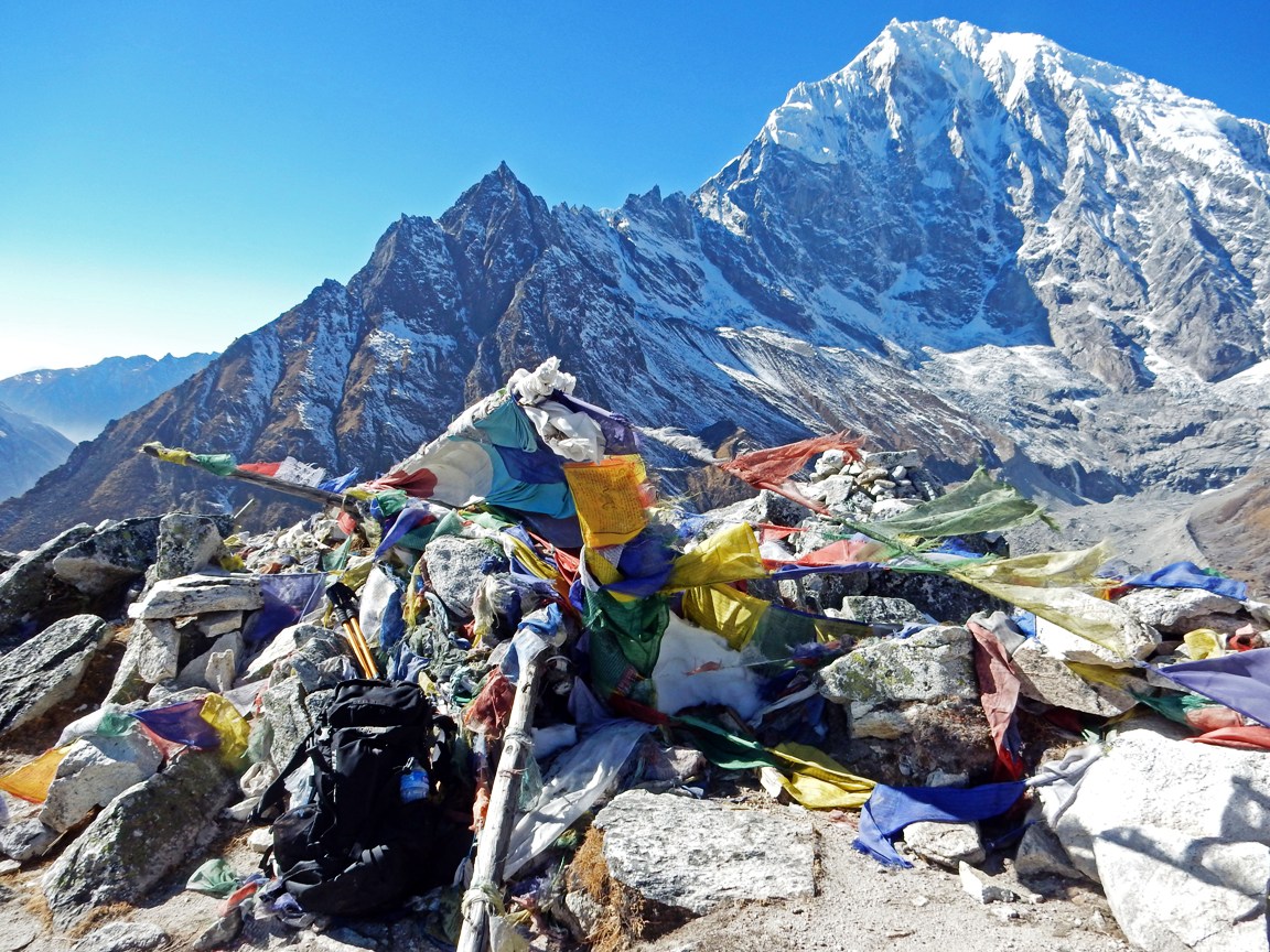
| Lantang Valley (February 2016) |
 |
| Lantang Valley (February 2016) |
 |
| Lantang Valley (February 2016) |
 |
| Lantang Valley (February 2016) |
 |
| Lantang Valley (February 2016) |

0 comments:
Post a Comment
Please support this blog by clicking those ads. Thank you.